IMD Weather Update: Heavy Rain, Thunderstorms and Heatwave Alerts Across India This Week
India is set to experience a mix of intense rainfall, thunderstorms, and heatwave conditions over the next few days, according to the latest bulletin from the India Meteorological Department. The forecast highlights how different parts of the country will face completely contrasting weather patterns at the same time, making this week particularly unpredictable.
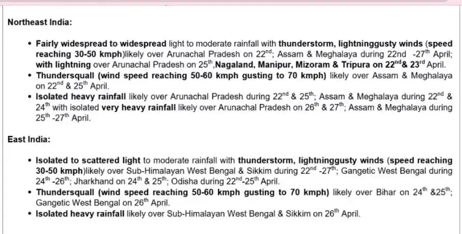
Northeast India braces for very heavy rainfall
The northeastern region is expected to witness the most intense weather activity. States like Assam and Meghalaya will receive widespread rainfall from April 22 to April 27.
Heavy rain is likely on April 22 and 24, while very heavy rainfall is expected between April 25 and April 27. In Arunachal Pradesh, heavy showers are forecast on April 22 and 25, followed by very heavy rainfall on April 26 and 27.
The IMD has also warned of thundersqualls in Assam and Meghalaya on April 22 and 25, with wind speeds of 50 to 60 kmph and gusts reaching up to 70 kmph. These conditions could lead to uprooted trees, local damage, power disruptions, and interruptions to daily life.
Eastern India to see thunderstorms and shifting weather
Eastern states will also experience unstable weather conditions. Sub-Himalayan West Bengal and Sikkim are likely to receive scattered to fairly widespread rainfall from April 22 to April 27, with intense rainfall expected on April 26.
In Gangetic West Bengal, rain and thunderstorms are forecast between April 24 and April 26. Odisha may witness thunderstorms from April 22 to April 25, while Jharkhand is expected to get rainfall on April 24 and 25.
Thundersquall warnings have also been issued for Bihar on April 24 and 25, and for Gangetic West Bengal on April 26, with similar wind speeds of up to 70 kmph.
Western disturbance to impact Himalayan regions
The northwest Himalayan region will be affected by a western disturbance starting April 23. Light to moderate rainfall or snowfall, along with thunderstorms and gusty winds, is expected in Jammu and Kashmir and Ladakh on April 24 and 25.
Himachal Pradesh is also likely to receive rain and thunderstorms on April 25 and 26. These conditions may affect travel and increase the risk of landslides in hilly areas.
Southern India to witness pre-monsoon showers
Southern states are expected to see pre-monsoon activity with scattered rainfall and thunderstorms. Telangana, coastal Andhra Pradesh, interior Karnataka, and nearby areas will likely receive rain between April 22 and April 25.
Rainfall is also forecast in Kerala and Mahe on April 22 and 23, while the Rayalaseema region may experience thunderstorms during the same period.
The IMD has noted that a cyclonic circulation over Telangana and a trough extending from central to southern India are driving these weather changes, leading to unstable atmospheric conditions.
Western India to get rain and possible hailstorms
Weather activity is also expected in western regions. Konkan and Goa, Madhya Maharashtra, and Marathwada are likely to receive scattered rainfall between April 22 and April 25.
There is also a possibility of hailstorms in Madhya Maharashtra on April 23 and 24, which could impact crops and local infrastructure.
Heatwave alerts remain a major concern
Even as several regions prepare for rain, heatwave conditions continue in other parts of the country. Alerts have been issued in Haryana, Chandigarh, Punjab, Uttar Pradesh, Madhya Pradesh, and Chhattisgarh throughout the week.
Rajasthan and Odisha are likely to experience heatwave conditions from April 23 to April 25, while Vidarbha may face similar conditions between April 24 and April 26. Bihar and Gangetic West Bengal have also seen heatwave conditions until April 22.
Hot and humid conditions in coastal areas
Apart from extreme heat, many coastal and eastern regions will experience hot and humid weather. This includes coastal Andhra Pradesh, Odisha, Tamil Nadu, Kerala, and Gangetic West Bengal.
Uncomfortable humidity is also expected in Konkan and Goa on April 23 and 24. Warm night conditions are likely in parts of northern India, including Haryana, Chandigarh, and Delhi, as well as some areas in Chhattisgarh and Odisha.
Temperature highlights
Recent data shows that Banda recorded a high of 44.2°C, making it one of the hottest places in the plains. Meanwhile, Najibabad recorded a minimum temperature of 17.5°C.
Safety advisory and possible impacts
The IMD has warned that heavy rainfall could lead to waterlogging in low-lying areas, traffic congestion, and poor visibility. There is also a risk of minor damage to weak structures and rural roads.
In hilly regions, landslides and mudslides are possible due to continuous rainfall. Strong winds during thunderstorms may cause damage to trees, power lines, and temporary structures.
What to expect in the coming days
Over the next three days, widespread rainfall is expected in Northeast India and the western Himalayan region, while scattered showers may occur in parts of Gujarat and western peninsular India.
At the same time, several regions will continue to face extreme heat. This unusual combination of heatwaves and thunderstorms in nearby areas highlights how dynamic and rapidly changing the current weather pattern is.
This week’s forecast reflects a complex weather system across India, where some regions will deal with heavy rain and storms, while others continue to face intense heat. Staying updated with local advisories and taking necessary precautions will be important in the days ahead.
Northeast India braces for very heavy rainfall
The northeastern region is expected to witness the most intense weather activity. States like Assam and Meghalaya will receive widespread rainfall from April 22 to April 27. Heavy rain is likely on April 22 and 24, while very heavy rainfall is expected between April 25 and April 27. In Arunachal Pradesh, heavy showers are forecast on April 22 and 25, followed by very heavy rainfall on April 26 and 27.
The IMD has also warned of thundersqualls in Assam and Meghalaya on April 22 and 25, with wind speeds of 50 to 60 kmph and gusts reaching up to 70 kmph. These conditions could lead to uprooted trees, local damage, power disruptions, and interruptions to daily life.
Eastern India to see thunderstorms and shifting weather
Eastern states will also experience unstable weather conditions. Sub-Himalayan West Bengal and Sikkim are likely to receive scattered to fairly widespread rainfall from April 22 to April 27, with intense rainfall expected on April 26.In Gangetic West Bengal, rain and thunderstorms are forecast between April 24 and April 26. Odisha may witness thunderstorms from April 22 to April 25, while Jharkhand is expected to get rainfall on April 24 and 25.
Thundersquall warnings have also been issued for Bihar on April 24 and 25, and for Gangetic West Bengal on April 26, with similar wind speeds of up to 70 kmph.
Western disturbance to impact Himalayan regions
The northwest Himalayan region will be affected by a western disturbance starting April 23. Light to moderate rainfall or snowfall, along with thunderstorms and gusty winds, is expected in Jammu and Kashmir and Ladakh on April 24 and 25.Himachal Pradesh is also likely to receive rain and thunderstorms on April 25 and 26. These conditions may affect travel and increase the risk of landslides in hilly areas.
Southern India to witness pre-monsoon showers
Southern states are expected to see pre-monsoon activity with scattered rainfall and thunderstorms. Telangana, coastal Andhra Pradesh, interior Karnataka, and nearby areas will likely receive rain between April 22 and April 25. Rainfall is also forecast in Kerala and Mahe on April 22 and 23, while the Rayalaseema region may experience thunderstorms during the same period.
The IMD has noted that a cyclonic circulation over Telangana and a trough extending from central to southern India are driving these weather changes, leading to unstable atmospheric conditions.
Western India to get rain and possible hailstorms
Weather activity is also expected in western regions. Konkan and Goa, Madhya Maharashtra, and Marathwada are likely to receive scattered rainfall between April 22 and April 25.There is also a possibility of hailstorms in Madhya Maharashtra on April 23 and 24, which could impact crops and local infrastructure.
Heatwave alerts remain a major concern
Even as several regions prepare for rain, heatwave conditions continue in other parts of the country. Alerts have been issued in Haryana, Chandigarh, Punjab, Uttar Pradesh, Madhya Pradesh, and Chhattisgarh throughout the week. Rajasthan and Odisha are likely to experience heatwave conditions from April 23 to April 25, while Vidarbha may face similar conditions between April 24 and April 26. Bihar and Gangetic West Bengal have also seen heatwave conditions until April 22.
Hot and humid conditions in coastal areas
Apart from extreme heat, many coastal and eastern regions will experience hot and humid weather. This includes coastal Andhra Pradesh, Odisha, Tamil Nadu, Kerala, and Gangetic West Bengal. Uncomfortable humidity is also expected in Konkan and Goa on April 23 and 24. Warm night conditions are likely in parts of northern India, including Haryana, Chandigarh, and Delhi, as well as some areas in Chhattisgarh and Odisha.
You may also like
- 'Public will punish Congress': BJP delegation meets EC over Kharge's 'terrorist' remark on PM Modi
- Kedarnath Yatra reopens April 22 with new safety rules
- India's early intense heatwave sees Banda Prayagraj, Maharashtra exceed 45°C
- UP CM Yogi Adityanath attacks TMC over cultural identity during BJP rally in Kolkata's Jorasanko
- Navi Mumbai airport due late April 2026 faces transport problems
Temperature highlights
Recent data shows that Banda recorded a high of 44.2°C, making it one of the hottest places in the plains. Meanwhile, Najibabad recorded a minimum temperature of 17.5°C. Safety advisory and possible impacts
The IMD has warned that heavy rainfall could lead to waterlogging in low-lying areas, traffic congestion, and poor visibility. There is also a risk of minor damage to weak structures and rural roads. In hilly regions, landslides and mudslides are possible due to continuous rainfall. Strong winds during thunderstorms may cause damage to trees, power lines, and temporary structures.
What to expect in the coming days
Over the next three days, widespread rainfall is expected in Northeast India and the western Himalayan region, while scattered showers may occur in parts of Gujarat and western peninsular India. At the same time, several regions will continue to face extreme heat. This unusual combination of heatwaves and thunderstorms in nearby areas highlights how dynamic and rapidly changing the current weather pattern is.
This week’s forecast reflects a complex weather system across India, where some regions will deal with heavy rain and storms, while others continue to face intense heat. Staying updated with local advisories and taking necessary precautions will be important in the days ahead.


More from our partners


Loving Newspoint? Download the app now