
Before and after: Satellite images show how Nepal's green mountainside turned into debris field


Satellite images taken before and after the deadly flash flood near Nepal’s border with Tibet reveal a striking change in the landscape: stretches of green mountainside visible before the disaster are now covered by a broad expanse of brown debris and sediment.
The Planet Labs imagery has provided early clues to how the disaster may have started. Experts examining the pictures believe that the lower section of a glacier broke away high in the mountains and plunged hundreds of metres into the valley below, likely carrying or entraining rock and sediment as it fell.
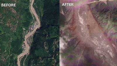
The Planet Labs imagery has provided early clues to how the disaster may have started. Experts examining the pictures believe that the lower section of a glacier broke away high in the mountains and plunged hundreds of metres into the valley below, likely carrying or entraining rock and sediment as it fell.
Next Story