
In 2016, airborne laser scans around Angkor revealed vast hidden roads, ponds and neighbourhoods, showing the Khmer capital stretched far beyond its famous temples


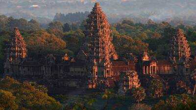
For more than a century, most people knew the grand capital of the Khmer Empire by what they saw from above, the vast stone temples of Angkor Wat and surrounding monuments. The common people of Angkor lived and moved along roads lined with houses and everyday structures built of wood and thatch, which rotted away centuries ago and left little for archaeologists to see sticking up out of the ground; thus, the temples never told the story of the huge urban environment that once surrounded them. It took a chopper with a laser on top to finally unveil what had been hiding below the Cambodian jungle canopy all along.
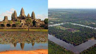
University of Sydney archaeologist Damian Evans had spent years collecting pieces of Angkor’s urban footprint via painstaking ground surveys before turning to a form of airborne laser scanning technology known as lidar. The first survey in 2012 scanned 370 square kilometres of the wider Angkor region, using a helicopter-mounted scanner that sent quick laser pulses into the ground, penetrating dense vegetation to record subtle differences in the earth's surface that showed traces of long-vanished roadways, canals and building platforms. Within that scanned area, the survey, published in the Proceedings of the National Academy of Sciences, more than tripled the confirmed footprint of Angkor's densely built city centre, from nine square kilometres of previously documented terrain to 35.
 A city bigger than anyone could have dreamed
The early successes led Evans and his team to return in 2015 to carry out what became the biggest airborne archaeological survey in history, spanning approximately 1,901 square kilometres of rainforest roughly the size of Greater London. The findings, published in the Journal of Archaeological Science in 2016, demonstrated that Angkor's full urban sprawl, well beyond that initial city-centre core, spread outwards in all directions for about 1,000 square km from its temple centre. Major temples were connected to residential districts beneath the forest canopy by a complicated rectilinear road system, and seasonal flood regions were spanned by raised road beds, with smaller side roads branching out into dwelling sections.
Perhaps most startling was discovering thousands of small rectangular lumps uniformly spread over what the scans identified as residential areas, the bases of wooden buildings that had originally been on raised platforms but left no trace either from the ground or from earlier satellite imagery.
The survey also showed a vast network of canals, channels and embankments running parallel to the road network, forming a sophisticated system of water management across the landscape, evidence of an urban civilisation engineering its environment on a scale far beyond that suggested by temple architecture alone. The study was funded by the European Research Council, which also backed the technical side of the project and later financed further rounds of Evans's lidar work across Southeast Asian archaeology
A retelling of the tale of a lost capital
The scans confirmed and extended earlier discoveries about Mahendraparvata , an early Khmer capital first identified in 2012 beneath the Phnom Kulen mountain, and showed it to be considerably larger than initial ground surveys had indicated, covering fifteen to twenty square miles of terrain now completely reclaimed by forest. The wider picture of Angkor's population, which some estimates suggest could have supported anything from 750,000 to a million people, made it comparable in scale to major cities anywhere in the world at the time, the researchers involved in the project said. It was a striking realisation for a civilisation whose visible remains had, for so long, been reduced to a handful of temple complexes.
The findings have changed the way that historians understand the rise and eventual destruction of Angkor. Researchers have given a new perspective to theories about the decline of the once mighty capital, suggesting that the later population growth of the empire put unsustainable pressure on its agricultural base. This is because they have a better understanding of how much of the surrounding landscape was used for residential and infrastructural purposes, rather than for rice farming. What began as an attempt to verify patchy evidence on the ground has produced one of the most complete views of a centuries-old Southeast Asian city to date, hidden in plain sight beneath a forest that has kept its secrets for the best part of six centuries.
University of Sydney archaeologist Damian Evans had spent years collecting pieces of Angkor’s urban footprint via painstaking ground surveys before turning to a form of airborne laser scanning technology known as lidar. The first survey in 2012 scanned 370 square kilometres of the wider Angkor region, using a helicopter-mounted scanner that sent quick laser pulses into the ground, penetrating dense vegetation to record subtle differences in the earth's surface that showed traces of long-vanished roadways, canals and building platforms. Within that scanned area, the survey, published in the Proceedings of the National Academy of Sciences, more than tripled the confirmed footprint of Angkor's densely built city centre, from nine square kilometres of previously documented terrain to 35.
The early successes led Evans and his team to return in 2015 to carry out what became the biggest airborne archaeological survey in history, spanning approximately 1,901 square kilometres of rainforest roughly the size of Greater London. The findings, published in the Journal of Archaeological Science in 2016, demonstrated that Angkor's full urban sprawl, well beyond that initial city-centre core, spread outwards in all directions for about 1,000 square km from its temple centre. Major temples were connected to residential districts beneath the forest canopy by a complicated rectilinear road system, and seasonal flood regions were spanned by raised road beds, with smaller side roads branching out into dwelling sections.
Perhaps most startling was discovering thousands of small rectangular lumps uniformly spread over what the scans identified as residential areas, the bases of wooden buildings that had originally been on raised platforms but left no trace either from the ground or from earlier satellite imagery.
The survey also showed a vast network of canals, channels and embankments running parallel to the road network, forming a sophisticated system of water management across the landscape, evidence of an urban civilisation engineering its environment on a scale far beyond that suggested by temple architecture alone. The study was funded by the European Research Council
A retelling of the tale of a lost capital
The scans confirmed and extended earlier discoveries about Mahendraparvata , an early Khmer capital first identified in 2012 beneath the Phnom Kulen mountain, and showed it to be considerably larger than initial ground surveys had indicated, covering fifteen to twenty square miles of terrain now completely reclaimed by forest. The wider picture of Angkor's population, which some estimates suggest could have supported anything from 750,000 to a million people, made it comparable in scale to major cities anywhere in the world at the time, the researchers involved in the project said. It was a striking realisation
The findings have changed the way that historians understand the rise and eventual destruction of Angkor. Researchers have given a new perspective to theories about the decline of the once mighty capital, suggesting that the later population growth of the empire put unsustainable pressure on its agricultural base. This is because they have a better understanding of how much of the surrounding landscape was used for residential and infrastructural purposes, rather than for rice farming. What began as an attempt to verify patchy evidence on the ground has produced one of the most complete views of a centuries-old Southeast Asian city to date, hidden in plain sight beneath a forest that has kept its secrets for the best part of six centuries.
Next Story